


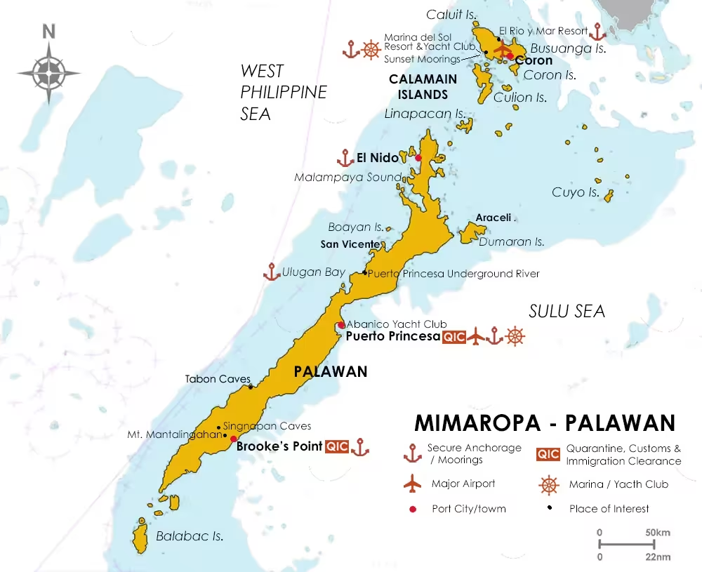
Sail Around Palawan
Palawan is the main route of arrival to the Philippines for yachts cruising up from Malaysia, Indonesia, Singapore, Thailand, Australia and the India Ocean. It is a long, narrow island stretching some 130 nautical miles (245kms) from 7°45'N to 11°24' between the West Philippine Sea and the Sulu Sea, marking the western border of the Philippines.
While the main island of Palawan is made up of many sheltered coves and beaches with a mountainous hinterland, Palawan Province is a collection of almost 1800 small islands, many of which are uninhabited and home to a rich diversity of marine life, indigenous species and flora. Because of this, it is often referred to as the Philippines 'last frontier' and remains relatively undeveloped, despite a major surge in resort and tourism infrastructure over the past decade.
For cruising yachts, Palawan offers a rich mix of populated areas, pristine islands and coastlines, where only the occasional fisherman may be found, with numerous sheltered anchorages. It is also located below the track of the vast majority of typhoons and tropical storms that sweep across the Philippines each year, and is recognised as among the safest cruising waters in the Philippines
Arriving From The West
Yachts entering the Philippines through Palawan have previously had the option of navigating up the East or West coasts, then checking in at Puerto Princesa, either directly if coming up the East coast or leaving their yacht at Ulugan Bay to travel overland to process and Quarantine Immigration and (QIC) Customs formalities. This latter, very flexible, option is now very much restricted and not always readily available, so best to check with authorities first (check-in Puerto Princesa). It is more likely that arrangements can be made for OIC staff to travel to Ulugan Bay to process the yacht and crew.
Alternatively, it is possible to check-in at Brooke's Point, near the southern end of the Palawan island, which offers an easier option for those wishing to explore the islands around Balabac Island and/or take a leisurely cruise up the West coast to explore its many deep bays, beaches, pristine waters and and wealth of wildlife.
Puerto Princesa (9°46'N, 118°44'E)
Located along the mid-east coast of Palawan, Puerto Princesa is the capitol of the Province of Palawan. It hosts Palawan's only international airport with daily flights to Manila and other destinations, and provides most facilities a cruising yacht may need, including banks, supermarkets, good telecommunication services, a yacht chandler and the Abanico Yacht Club with managed moorings. There are also recognized anchorages immediately West of the Abanico Yacht Club and off the Baywalk Park (see StP link). Puerto Princesa Bay is considered to be typhoon-safe except for a direct hit by a storm (a rarity).
Puerto Princesa makes for a safe and secure jumping-off point to explore many of Palawan's attractions. To the North, Honda Bay and Pambato Reef are just a day trip away and are known for their abundant marine life and picturesque sand-bar islands. Pambato Reef Marine Sanctuary, which embraces a large portion of the Honda Bay area, offers an insight into the abundance and diversity of coral and marine life that you can expect to explore around the islands that you will visit as you voyage further North to El Nido and onto Coron and Busuanga.
The Puerto Princesa Underground River, which is the longest navigable underground river in the World and is listed as one of the "New 7 Wonders of Nature" is also a relatively short and very scenic road-trip away.
North to El Nido
After leaving Puerto Princesa, your next probable stopover will be at the Verde Islands (North Verde and South Verde), about 30 nautical miles (56 kms) north of Puerto Princesa. Stopping here will provide sheltered anchorage in the lee of deeply forested islands, offering the prospect of a morning chorus of bird song.
Departing the Verde Islands, you quickly encounter Green Island Bay. The Bay is populated by traditional fishing villages, so expect to be offered fresh fish for sale wherever you choose to drop anchor. When selecting an anchorage, always check your charts for good bottom holding, ensure that there are no coral heads or rocks close to the surface and take care not to damage coral or local fish traps. "Green Island" the eastern-most island in the group is no longer truly green, as the resident fishing community has expanded over the centuries to occupy virtually the entire island.
Dumaran & Araceli
Onward northeast to Dumaran Island. Dumaran Island embraces the municipality of Araceli (North & East of the island) and part of Dumaran municipality, that extends West onto Palawan Island. Dumaran Island is famous for white sand beaches and having almost no tourists. They are also home to a sub-specie of the curacha crab (Ranina ranina) - a culinary specialty that you may not have come across before. The curacha crab has a unique body shape and contains more flesh than other crabs for its size.
You can sail the Dumaran Channel, between Dumaran Island and Palawan Island, or you can sail East-around to Araceli. If in a hurry to get to El Nido, take the Channel, but if exploring pristine beaches and snorkeling over a diversity of coral, then take the eastern route.
East of, and administratively part of, Araceli are the three uninhabited islands of Langoy, Manulali and Catad. These offer a glimpse of the dramatic geological landscapes, made up of white sand beaches, steep cliffs and forest hilltops punctuated by jagged limestone pinnacles, which become more prominent the farther you voyage North.
Head NNW from Catad Island and within 35 nautical miles (50kms) you enter the maze of islands that are sprinkled into the Sulu Sea at the northern extent of Palawan Island. Your next destination for supplies will probably be the town of El Nido on the NW corner of Palawan Island, unless you are heading further North to Coron and Busuanga.
El Nido (11° 11'N, 119° 42'E)
The Northwest of Palawan around El Nido has become one of the Philippines' most visited tourist destinations, largely due to the combination of dramatic, rugged rock formations, secluded white-sand fringed coves and the diverse marine life that is easily observed from the rail or when snorkelling. It is also one of the Philippines' prominent diving destinations,
The town of El Nido features a domestic airport with regular flights to Manila, Caticlan (for Boracay), Cebu City, Angeles (Clark) and Busuanga (Coron). There are half a dozen ATMs in the town, at least two national banks (BPI and RCBC) and a number of licensed money changers. You can also stock up on most food supplies and top-up diesel and/or gasoline tanks.
There are no developed marinas or reported managed moorings around El Nido, so anchoring is required. Please observe best anchoring practices to avoid coral damage (see StP link).
There is also good public transport overland from El Nido to Puerto Princesa that can be used if you need items from the yacht chandler or to extend tourist visas with Bureau of Immigration, as there is currently no Bureau of Immigration office in El Nido.
The Northwest of Palawan offers year-round cruising, but the northeast monsoon season (Amihan) provides more anchorages and more stable weather patterns. Water clarity is best between December and March. Heading south from El Nido the bays offer a mixture of karst landscapes and pristine beaches with National parks and lots of great diving and snorkelling. Tidal range in this area is seldom more than 1.3 metres, and you will find some of the best cruising in the Philippines here, with few people, little development of the picturesque bays and, most importantly, safe typhoon anchorages.
South From El Nido
After escaping the lure of the many islands surrounding El Nido you quickly arrive at the entrance to Malampaya Sound. Malampaya Sound is a large bay that extends 18 nautical miles (33kms) inland. While it is the location of the Philippines' largest natural gas extraction point, it is also a protected habitat for marine and on-land eco-systems. Anchoring within the Sound is not allowed except at the islands that mark its entrance. Anchor at the islands and take your dinghy to see if you can observe the endangered Irrawady Dolphin and a number of Philippine endemic species in their natural habitats.
From Malampaya Sound the next notable destination is Boayan Island, in the municipality of San Vicente. Boayan Island is largely undeveloped as it is a protected environment. It features a wide variety of indigenous wildlife within its forested interior, plus enchanting marine habitats offshore. If you want to explore the island, local guides are available and anchoring off the fishing village in the SW corner of the island and going ashore is the best option. You may also be able to take a guide on board and have them direct you to other approved anchorages.
On Palawan proper, San Vicente municipality abounds with small sheltered bays and islets, but property developers have expanded into many corners, offering vacation homes to wealthy Filipinos.
Next up, if you did not take the road trip from Puerto Princesa, is the Puerto Princesa Underground River. At the risk of repeating, the Puerto Princesa Underground River is one of the 'New 7 Wonders of Nature' and you really should not miss the adventure and spectacle of entering the cave and marvelling at the geology, even if only to tick it off your bucket list.
Ulugan Bay
Less than 10 nautical miles (19kms) farther southwest is Ulugan Bay. As mentioned above, this Bay has sometimes been used in the past as an anchorage for yachts checking in to the Philippines on the West coast of Palawan. It is still possible to pre-arrange on advance for yachts to anchor in Ulugan Bay and request visitation from QIC staff based in Puerto Princesa (check-in Puerto Princesa). The QIC staff will charge a visitation fee for the services offered.
Ulugan Bay is also notable for is the shelter it offers if a tropical storm or typhoon should approach the area. Because of this the Philippine Navy has had a long-established base on its western shore and has recently welcomed US Forces to join them as they protect the right of safe passage and navigation through the West Philippine Sea and the more distant South China Sea.
Tabon Caves
For the next 60 nautical miles (111kms) there is not a lot to explore, unless you wish to visit the occasional fishing village for fresh seafood, until you reach Malabut Bay. Here, the Tabon Caves on the western shore are the location of one of the only two known prehistoric settlements in the Philippines. Human remains, tools and artifacts, including the Manunggul Burial Jar, show a long period of habitation dating back from as little as 700 to 47,000 years ago.
There are more than 200 caves within the Tabon Caves limestone complex, but as not all have been fully explored or documented visitors are only allowed guided access to less than 10 of these caves. Dubbed the 'Cradle of Philippine Civilization', the caves provide some of the oldest and most important insights into the life of early humans in Southeast Asia.
Today, the caves are now only occasionally home to their namesake, the Tabon Bird (Megapodius cumingii), so named after its propensity to cover its nest after laying its eggs (for more, see Sibale Island, Romblon).
If you have an interest in ancient cultures, you might like to visit the Singnapan Valley in the shadow of Palawan's highest mountain, Mount Mantalingahan. Petrographs found in the Singnapan Caves date back to the Paleolithic era. Located in the municipality of Rizal, the caves are still the seasonal home of the indigenous Tau't Bato minority, who are also known as the Palawano, and have ancient roots in southern Palawan. There are more than nine indigenous groups living in Palawan and of these, the Tau't Bato and Tagbanua are considered to be possible descendants of the original Tabon cave dwellers.
These groups live in remote villages throughout Palawan in the mountains and coastal areas, and many still dress in their distinctive styles, speak their own languages and practice traditional agriculture, and hunting & gathering practices.
Once you leave Rizal you are approaching Balabac Island at the southern tip of Palawan island. It is well shielded on two sides by smaller islands and offers a number of good anchorages. The islands are sparsely populated and the surrounding waters offer a wealth of extravagant marine environments that attract a huge diversity of Mother Nature's most inspiring creatures. It is recommended to approach the islands in daylight, as there are many sandbars and small islets that are not well-marked on charts. The tidal currents can also be very strong in places as water from the Sulu Sea pushes through the narrow strait between the Palawan and Sabah coasts.
From here, unless you are just arriving in the Philippines, the next stop is normally Kudat or Kota Kinabalu in Malaysia, then on to the rest of Sabah, followed by Brunei, Sarawak, Singapore, Indonesia and beyond. If you are arriving in the Philippines QIC regulations are much stricter than in pre-COVID years and it is best to give Balabac a wide berth and head directly for your arranged check-in destination.
As mentioned above, arriving yachts should also be able to arrange QIC formalities at Brooke's Point 9.24425 and choose to reverse the above navigation of Palawan, sailing back through the Balabac Islands, then up the West coast first. Yachts travelling up the West coast may also have the option of clearing at Ulugan Bay (see StP link).
Brooke's Point (8°46' N 117°50' E)
If you have made arrangements to check-in and do QIC clearance at Brooke's Point), it is best to do a straight overnight run direct to the port. There should be little need to stock up or replenish provisions or fuel at this stage of the journey, but Brooke's Point does provide basics. There are also a number of local banks and money changers.
Brooke's Point is a busy port with regular International (Sabah, Brunei, Malaysia and Indonesia) and domestic shipping (Manila, Visayas, Mindanao and Palawan). The recent development of extensive, but controversial, Nickel mining operations there has also increased the port's activity and facilities with export shipping to China. The port also supports large commercial fishing operations. There is even a fibre optic internet service and WiFi.
Traditionally, Brooke's Point is home to a large indigenous minority population and is a agricultural-based economy. While it should be an ideal candidate for extensive eco-tourism as a part of the Tribal Zones and Ancestral Domains of Palawan and the location of the Mt. Mantalingahan Protected Landscape, it has not happened. Brookes Point attracts few recreational visitors and has almost no tourism facilities.
That said, if you should need to spend a couple of days, for whatever reason, in Brooke's Point there is still plentiful wildlife, endemic bird species, extensive natural forests, waterfalls, pristine beaches and coral reefs to explore.
Historically, Brooke's Point is known for the Pearl of Lao Tzu, the world's largest pearl found by a local fisherman in 1934 and its namesake; the famous 'White Rajah' Brooke of Sarawak, who journeyed here in the 1830s and reportedly built the lighthouse that still stands today.
Palawan's Southwest Coast
From Brooke's Point you can now go south through the Balabac islands described above to navigate Palawans' West coast or North onto Puerto Princesa.
Heading north, the coast is a patchwork of small islands and reefs, and most yachts will make the voyage to Puerto Princesa in one hit. This is partly because there are not so many notable locations along the coast and partly because there are numerous poorly publicized Marine Protected Areas where anchoring is prohibited.
One place of interest may be the King's Paradise Island Resort. This once up-market resort on a small forested island off Barangay Panatian closed its doors during the COVID pandemic and never reopened (currently for sale August, 2025). Anchoring off the beach on the northwest corner of the island, close to the resort itself, is the only option to avoid the rocks and coral reefs.
If you are voyaging to Puerto Princesa between July and December you may be interested to know that about 35 nautical miles (65kms) before you reach Puerto Princesa you will pass Rasa Island, a protected environment island where the Philippine Cockatoo (Cacatua haematuropygia) is being slowly saved from extinction. From January to June visits to the island are forbidden to protect the cockatoos and other avian and marine residents during the primary breeding season. To visit Rasa Island you need to anchor off the town of Panacan, near Panacan Pier (N9.24425, E118.41512) and engage a tour guide.
North from Palawan Island
Stretching further North from Palawan and reaching towards the large island of Mindoro are the Calamian Islands, a series of small and not-so-small island groups. Like Palawan itself, these are less developed and populated than the rest of the Philippines and offer the same spectacular tropical island landscapes above and below the water. Equally, there is much to explore, discover and enjoy within short distances and relative solitude for the cruising yacht.
Calamian Islands
The Calamian Island group numbers more than 300 islands, the largest of which is the Busuanga Island, group with the most visually dramatic group being Coron Island, and the least developed and closest to Palawan Island, the Linapacan Island group.
Linapacan Island
Linapacan Island, and the fifty or more smaller islands that surround it, are located in the south of the Calamian Islands. Linapacan is relatively unique in the Philippines in that its stunning vistas of white sand beaches, waving coconut palms, protected coves, crystal clear waters and pristine forest interiors have not been developed as a major tourism destination. However, lacking even basic infrastructure such as reliable power, an airport and reliable telecommunications have meant that El Nido and Busuanga/Coron have dominated instead.
Stopping over at Linapacan Islands, or one or more of its many smaller companions, is a delight, but please observe safe anchoring practices (see StP link) to protect the marine ecosystems so that those who follow and future generations can share your pleasure.
Voyaging northeast from Linapacan Island you cannot avoid the vista of Culion Island on the horizon. Culion is a large Island with bountiful waters and a robust and vibrant marine ecosystem, created and maintained by a sprawling perimeter of mangroves, seagrass, and corals.
Culion Island
Culion Island is also and island with a dark medical history as a leper colony, for no other reason than it is a large, remote island and almost uninhabited at the time. During the period of United States administration of the Philippines (from 1899 to 1946) anyone diagnosed with leprosy, anywhere in the Philippines, was unceremoniously taken from their family and shipped off to Culion Island. Up to and until the 1980s, when a cure for leprosy was finally found, the Department of Health owned and administered close to 100% of the island and only medical practitioners and suppliers were permitted to land at barangay Libis on the northeast coast of the island. In 2006 the island was officially declared to be leprosy-free by the World Health Organization, hence the only modest development and relatively small population increase since.
At the turn of this century there was a plan to re-purpose Culion Island into a self-contained tourist island, with an international airport, five-star hotels and resorts - pretty much everything a viable commercial tropical paradise would need to compete on the World stage. Unfortunately, or fortunately depending on your point of view, the project was side-lined, but it may still happen, one day . . . so enjoy its pristine offerings while you still can.
Just north of Culion Island is Calamain's largest island, Busuanga. This is a tourism destination that rivals El Nido and is known internationally for the many wrecks of Japanese ships that were sunk on September 24, 1944, in the last days of WWII by US Navy airplanes.
While these wrecks have put Busuanga on the international wreck-diving map, it has much more to offer and other, unique reasons to visit. As well as its pristine waters, numbers & diversity of marine life, and dramatic geological features, there are hot-springs in the mangroves, hidden lakes & tumbling down hillsides, a wealth of endemic and migratory birds, and an island where indigenous African animals graze alongside endangered Philippine endemic species, and then there is Coron Island..
Coron Island
Coron Island is Busuanga's eastern-most group and is essentially a no-go zone for visitors unless accompanied by a guide from the indigenous Tagbanua group, who claim the island as their ancestral domain. The Tagbanua are one of the oldest indigenous groups of the Philippine archipelago and can trace their history back to 22,000BC and beyond. If you are interested in indigenous groups and culture, it is well worth taking the time to arrange a visit if you can.
Coron Island has similar geology to that of EL Nido – rugged rock formations rising almost vertically from the sea – and embraces numerous freshwater lakes as well as tidal-lakes & caves. The Island also gives its name to the municipality that encompasses the eastern half of Busuanga Island and Coron town, not to be confused with Coron Island, is Busuanga's largest population and commercial centre. It has an airport with regular flights to Manila, a variety of hotels, restaurants and tourism services, and is the stepping-off point to most of Busuanga's resorts and dive operations. It also has adequate supplies of basic food supplies and fuel, and relatively protected anchorages.
Busuanga Island
There is not much of interest along the exposed East coast of Busuanga, but the South, West and North coasts are chock-full of attractive places of interest, and exploring them should be considered mandatory.
A word of warning. Along the bays and islets dotting the southern shores of Busuanga you will observe what appear to be fish farms. However, they are actually pearl farms and cannot be navigated safely, so daytime-only sailing is a must in these locations.
Managed moorings can be found on the southwest corner of Busuanga at the Marina del Sol Resort & Yacht Club and, in the adjacent bay, at the Sunset Moorings. Also, along the North coast of Busuanga Island, more managed moorings are available at the El Rio y Mar Resort. To get from Sunset Moorings to El Rio y Mar you have to sail North past Black Island and Calauit Island - located on the northwest corner of Busuanga Island.
Black Island, almost the western-most Island in the Calamian Group, is notable for being slender and tall, but it also boasts a mystery. Black Island has two caves facing East. Close to these, just offshore, are the remains of a small Japanese boat that was one of those sunk in 1944. There is a submerged tunnel inside the southern cave with old, but unexplained, markings that extend through to the dry portion of the cave, that ends suddenly at an unmarked wall. Local lore claims that this might be one of the hiding places of Yamashita's gold and that the small Japanese boat was on a mission to hide the gold inside the cave for later retrieval!
Moving along to Calauit Island you will find African Zebra and Giraffes grazing peacefully alongside endangered Calamian Deer. These are the legacy and all that remains of an attempt by former Philippine President Ferdinand Marcos and First Lady Imelda Marcos to create an African game reserve in the Philippines in 1976. Originally, there were many more African species, including Waterbuck, Eland, Impala, Topi, Bushbuck, and Thomson's Gazelle, but these have since died out. However, the 3,900 hectare nature reserve was re-imagined by local officials in the 1980s to conserve indigenous species and has resulted in the successful conservation of Calamian Deer, Palawan Bearded Pig, Philippine Crocodile, Philippine Porcupine, Binturong, Philippine Mouse-deer and Hawksbill turtles.
A very unique program and well worth dropping anchor to visit.