


Where Can I Sail in The Philippines?
The Philippines has 7641 islands located in an area of the West Pacific measuring approximately 1,000 nautical miles North to South and 520 nautical miles East to West, and you can sail freely almost anywhere around and between the islands. The Law of the Philippines enshrines its waters and its beaches (up to at least 3 meters above high water and farther above high-water in some cases) as providing public right-of-way, in other words you can sail almost anywhere in the Philippines. There are only a few areas where you are not allowed to sail freely - see "Restricted Areas" below.
If you do not yet own a boat or a yacht then go to the Sailing Clubs & Yacht Clubs page where you will find information about all of the places where you can learn to sail or where you can meet boat & yacht owners and join in with some sailing fun. If you own a boat or a yacht then the information and maps on the following pages will be your guide to all areas for sailing in the Philippines.
Popular Sailing Areas Philippines
The Philippines is divided into three major administrative Regions: Luzon, Visayas and Mindanao. Each Region contains multiple Provinces and Municipalities. These website pages are a condensed version of cruising information spanning the past 40 years. If you wish to provide new information that will help those that follow, please contact us.
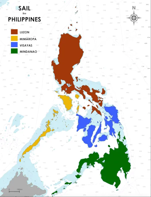
The central and western islands of the Philippines are the most popular sailing areas. The main reason for the popularity is the seasonal weather that favors the period from October to April, when the northeast monsoon is dominant. The northeast monsoon makes the West facing coasts more attractive. During the northeast monsoon the East facing coasts receive the (frequently) strong, onshore breezes and there are not so many places to hide from a big blow.
Sail Luzon Information
Luzon Island is the largest island in the Philippines and, with its many bays and inlets, offers approximately 2,700 nautical miles of coastline to explore. With a few exceptions, only the West coast is typically explored by cruising yachts because the East coast has fewer towns, villages and, perhaps more important, fewer places for a yacht to hide from any inclement weather. The most popular exceptions on the East coast are in the Provinces of Sorsogon and Albay, in the southern portion of Luzon Island.
Sail MIMAROPA Information
MIMAROPA is the acronym for four of the most interesting island groups in the Philippines: Mindoro, Marinduque, Romblon and Palawan. Other islands of note within the group are Sibuyan, Sibale, Banton, Tablas, Busuanga and Coron. Between them the MIMAROPA island groups offer exploration of forested mountains, waterfalls, indigenous flora, animals and birds and, being at the apex of the renowned "Coral Triangle", they offer some of the most diverse and exotic marine life on the planet for snorkelers and scuba divers to discover.
Sail Visayas Information
The Visayas encompasses the majority of the islands in the Central Philippines and in many ways are the entry point to the archipelago, or at least it was the entry point in 1521 for Ferdinand Magellan when he sailed across the Pacific Ocean seeking a new route to the Spice Islands. It was Magellan who gave the archipelago its name - The Philippine Islands - after the then Prince Philip, later King Philip II of Spain. From the mountainous island of Samar in the East to the bio-diverse Negros in the West, the Visayas are packed full of history and island beauty. The primary islands in the Visayas are: Samar, Leyte, Cebu, Negros, Bohol and Panay. The smaller islands you may also want to visit include: Guimaras, Biliran, Siquijor, Bantayan, Apo and Boracay.
Sail Mindanao Information
Mindanao has the longest coastline of any Philippine island by virtue of so many bays and inlets. Mindanao also contains some of the most interesting early sailing pre-history of the archipelago in Butuan, which was famous for building fleets of sailing boats known as "balangay", used mostly for inter-island travel. Mindanao is also home to the tallest mountain in the Philippines (Mount Apo) and features some of the country's broadest biodiversity and most colorful cultural traditions, plus one of the top-ten surf-breaks on the planet (Cloud Nine). Other notable island around Mindanao worhty of your time include: Samal, Siargao, Bucas Grande, Dinagat and Camigin.
Restricted Areas
You are not allowed to sail in close proximity to military bases; and, there are some minor restrictions when sailing inside Special Economic Zones, e.g. inside the waters of the Subic Bay Metropolitan Authority (SBMA). Also, you should consult nautical charts issued by the National Mapping and Resource Information Authority (NAMRIA) to locate Traffic Separation Zones that may lay along your proposed routes, e.g. within sections of the Verde Island Passage between the islands of Luzon and Mindoro.
Philippine Ports Authority
The Philippine Ports Authority is responsible for all commercial ports. If you are entering a commercial port area (easily identifiable by the presence of cargo and or large passenger ships) then you should hail the Port on Marine VHF Channel 16 to advise them of your location and purpose. In almost all cases, you will need good reason to be navigating inside a commercial port area.
Subic Bay Metropolitan Authority (SBMA)
The area of water inside Subic Bay that is under the jurisdiction of the Subic Bay Port Authority - anywhere North from Grande Island - and may have traffic separation zones and specified anchorage or berthing for commercial shipping. As a recreational yacht you are required to radio your intentions to the Port Authority (hailing frequency Marine VHF Channel 16) upon entry and exit from the Bay. Also, if you are planning to berth or moor within the SBMA waters - extending from Grande Island to the lighthouse at the mouth of the Santa Rita River and everything East thereof - then you are also required to register your arrival & departure by completing arrival & departure forms and presenting same to the Port Authority.
You are not permitted to anchor within the area controlled directly by the SBMA without the express permission of the Subic Bay Port Authority. You can anchor in the waters to the West of the area controlled by SBMA - see Moorings & Anchorages Subic Bay
If you have questions after reading the above then check out our Frequently Ask Questions section